How To Research Property Boundaries
Earlier this year, Mrs. C. and I purchased a section of abandoned railroad bed from the previous owner for $3,500. This section is listed as being 4.5 acres and runs approx. 3,000 feet at a width of 66′. Before we purchased the property we did some research to figure out exactly what we were getting and where the boundaries are. I recently found out that our original research was flawed and we actually owned more than we thought we did.
History of the Railroad Bed:
In 1882 The Cincinnati, Wabash, and Michigan Railroad expanded it’s railroad from Niles, MI to Benton Harbor, MI, connecting to the recently built ship canal that Benton Harbor was named for. This railroad lasted for about 100 years and its ownership changed multiple times as well. During its tenure it shipped cars loaded primarily with fruit and washing machines from Benton Harbor, and was also a passenger rail for a time. In the early 80s the rails were taken up and in 1984 the section behind my house was sold to the land owner who at the time owned most of the land to the East of the railroad bed. He had purchased it to sell the railroad ties that the railroad left behind. Over time, that family has since sold off the vast majority of its land, including all of it that was adjacent to the railroad bed. His grandson, who inherited the property recently has no use for the property and offered to sell it to us.
My Original Research On The Property Boundaries:
GIS Mapping:
My county has a GIS mapping program that they allow access to for $15 a day or $50 per month. This program gives a parcel map of the entire county that is also searchable. The plat map showed the property boundaries and can be viewed with a layer from google earth showing the images of the land. It also gives property descriptions and owner information. Using this software I was able to see the approximate boundaries of the railroad bed. Our North boundary was drawn along the North section line with the adjacent two properties, so of course I figured that this is where the boundary actually is. The measuring tool on the GIS system showed me a slight problem. The measurement from what is marked as the north line to the south line was 2,750 feet, which at a width of 66 feet (33′ from the track center on both sides), only equals 181,500 square feet, or 4.16 acres. This is far short of the 4.5 acres listed in the property description. When I purchased the property I really didn’t care about this discrepancy much because it covered the area I was most concerned about, that which was directly behind my house. These GIS mapping sites have disclaimers on them because they can be off by a bit here or there and are an approximation. The real boundaries are what is written in the land descriptions.
My Further Research On The Property Boundaries:
Examining Property Boundary Descriptions:
Most property descriptions are extremely difficult to read, but are all based on the land surveys conducted well over 150 years ago in this area. Land in the United States West of the original 13 colonies is broken up into townships which typically contain 36 square mile sections, which can be further subdivided into quarter sections. These sections have markers made of concrete and steel at the corners and all property descriptions are written using these as the reference points….except in some rare cases….like railroad beds.
Since the plat map showed my property along the section line with the adjacent properties, I assumed the description would state something along the lines of “terminating at the north line of section 10”, after all, both adjoining properties state similar language. My property states “ABANDONED RR R/W IN SEC’S 3 & 10 T5S R18W COM AT E & W 1/4 LN SEC 10 & RUNNING NLY TO MILE POST 6+5110.5MOL”
Okay, so the first thing that sticks out is that the language states in sections 3 AND 10, which means my property extends beyond the section line into section 3. The property starts at the 1/4 section line in section 10 and runs northerly to mile post 6 + 5,110.5 feet (More Or Less). The 1/4 section line was easy enough to discern, but what is all this jargon about mile posts?
Railroad Mile Posts:
Railroads, like highways, post mile markers so that train conductors have an idea of where they are at. But these mile posts had to have been put in 130 years ago, would it be logical to believe I could still find them to plot out where our boundary is using this information?
I did a bit of online research and found that most railroads used large concrete posts for mile posts. These would be a pain in the ass to move and would have no value as scrap. Since this land is undeveloped I figured it would be likely the posts still existed. While researching mile posts I found a link that provided me with a government database of all railroad crossings in the US. This list is searchable and I was able to pull up the files from this railroad, dated 1984, the year the railroad bed was sold to the previous owner. The government has a separate report for each crossing and lists the railroad mile mark each crossing is at. I was able to use this data to show that the mile marks started in Benton Harbor, MI and worked their way South, meaning that mile marker 6 would be well north of my property and that mile marker 7 should be on my property.
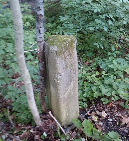 I measured out on the map where the mile marker should be based on the crossroad intersections for the rail bed. Within 10 minutes of searching I came across the mile post, but it did not have a label on it anymore, I then located Post 8, but once again no marking. The mile post I found, which has to be mile post 7, is 20′ south of the bridge over the large creek and about 100′ north of where I thought our property line was. Since the property description states Mile Post 6 + 5,110.5 feet, then Mile Post 7 – 169.5 feet would be the same spot. 20 feet takes me to the bridge, 90 feet crosses the bridge and I have another 60 feet on the north side of the bridge. When doing the math with this distance added in, I have 3,020 feet in length X 66 feet in width resulting in 4.5 Acres.
Register Of Deeds:
My county has a register of deeds website that has a searchable database that allows access to all their deeds on file. By using this system I was able to pull up the original deed to my railroad property and to the property on our North boundary. Both of these deeds included a map showing the exact border at the same location I found by measuring from the mile post myself. Combined with my independent field research I am now completely confident where the property boundary is.
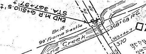
Pretty Clear where the boundary is…Also shows mile post 7 as existing right where I found it at.
More Creek Frontage
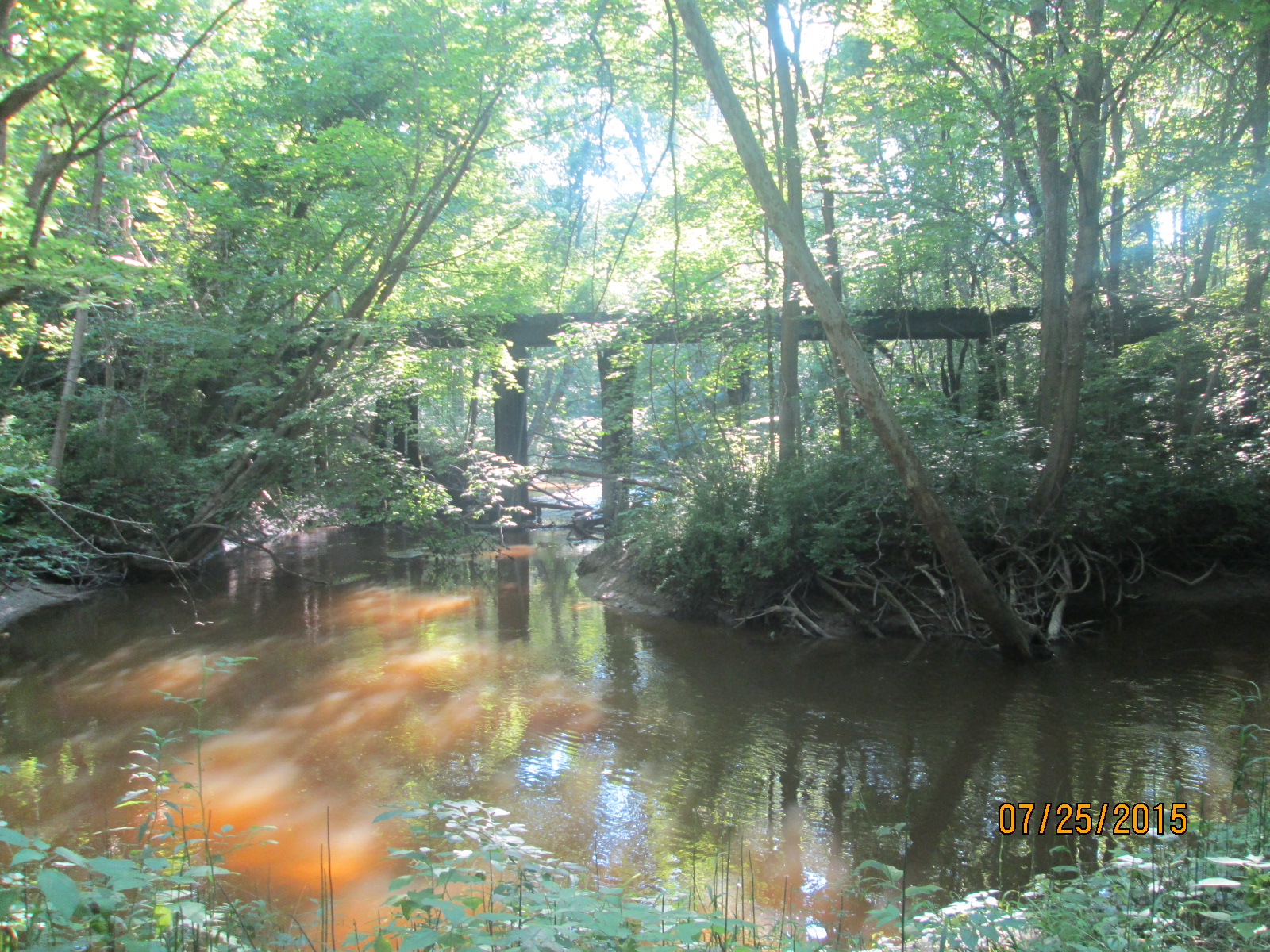
An added bonus is that the large creek makes a 90 degree turn and follows the edge of the railroad bed on the north side. Instead of having 66 feet of creek access where the creek crosses the property, I have another 70 feet where it runs adjacent to it. 135′ of creek frontage when I thought I had 0 is a big win. This will be nice for fishing, exploring, and in the future kayaking. This creek flows into the St. Joseph river, which runs about 7 miles into Lake Michigan from the mouth of this creek.
The Downside:
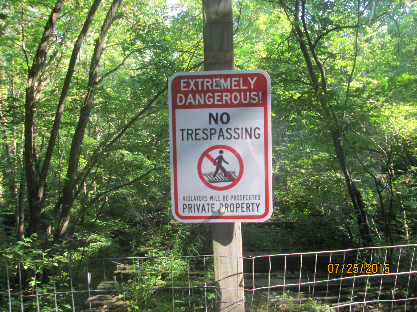 By “gaining” this extra property I also gain the liability of the bridge. The bridge is probably 20 feet over the creek, is roughly 90 feet long, and in bad repair (it is over 130 years old). On the south side there is about a 10 foot gap between the bridge and the land because the side of the creek has washed away the bank. I have seen signs that people have been on this bridge and if someone were to injure themselves it would be a potential liability to me. I spent a weekend building a fence around the bridge and posting signs that warn of extreme danger and private property. This fence is approx. 5′ tall and is constructed of welded wire field fencing. If I notice damage to the fence or more signs of people still using the bridge I will build a strong 6 to 8 foot tall chain link fence on the actual property boundaries. My estimated cost for building this fence is around $500, which will be worth if it keeps someone from getting hurt. I will also be making a few basic repairs to make the bridge a bit safer. There are two 6X6 beam ties that someone purposefully removed from the bridge, I plan to replace these (the beams are in OK condition and are under the bridge right now), as well as build a bridge extension to the south side over the 10′ gap.
Last week I spent some time widening the trail I had carved through the bed and made a video showing the property. The camera is a bit shaky, but the video gives a better understanding of the property as a whole.
Have you ever looked into your official property boundaries? Did you gain or lose based on your original perceptions?
Leave a Reply